Did You Know That Continents Move 10 cm a Year?
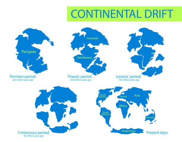
Millions of years ago, there were no separate continents as there are now. The earth consisted of one big continent that gradually broke up and drifted apart to form the continents of Asia, Africa, Australia, the Americas, Antarctica and Europe. The continents are still moving! Scientists believe that Earth’s continents began moving apart million of years ago and they are still moving! Let’s discover how it happened and why it’s still happening?
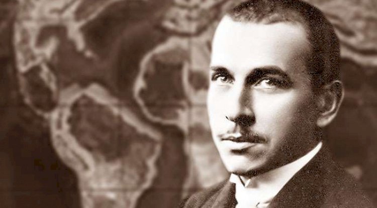
It was a German scientist called Alfred Wegener who first proposed the Continental Drift theory, explaining the moment of the continents. One day, when Wegener was looking at a map of the world, he realised that the coastlines of eastern South America and western Africa would fit into each other perfectly if he brought them close together. The coastlines of Greenland and Eurasia are also matched similarly, while he was teaching at the University of Marburg in 1911, Wegener found a research paper in the library that listed the identical fossils found on both sides of the Atlantic Ocean! Mystified, he looked for more evidence and found that features like mountains and valleys in South America and Africa were also the same!
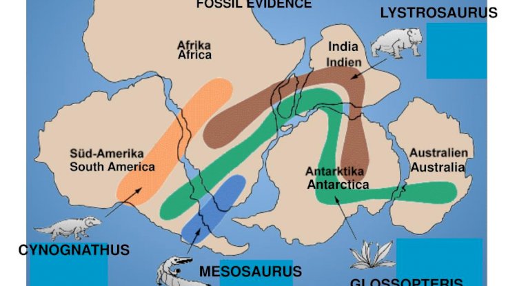
Other scientists also noticed the identical fossils of animals and plants on two different continents. But they believed it was because there were once land bridges connecting the continents which enabled the animals on one side to cross the sea over to the other side. Wegener believed that 300 million years ago, there was a supercontinent “Pangaea” which gradually broke up. He publishes his “Continental Drift” theory in 1915. This theory says the bridges sank into the oceans, separating the continents permanently. He felt that this didn’t explain the matching physical feature, the presence of fossilised tropical ferns in the Arctic or the identical marks left by retreating glaciers in both South Africa and South America.
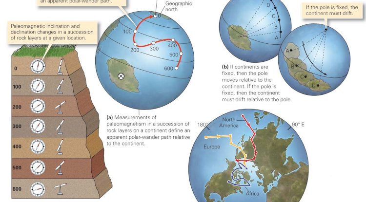
Then in the 1950s and 60s, palaeomagnetism, the study of the magnetic properties of rocks which show how Earth’s magnetic field has changed over millions of years, revived the continental drift theory. Unfortunately, Wegener died before he could investigate further. Earth has a strong magnetic field. When rocks are formed, as when lava cools after a volcanic eruption, the magnetic minerals in the rocks preserve the memory of the magnetic field at that time. Geophysicists compared the magnetic fields in volcanic rocks of different ages with the help of a magnetometer. They discovered, that over the ages, the direction of the magnetic north pole had moved around quite a bit. Has the pole moved or had the continents moved? Since the polar wander paths on different continents have moved about the north pole and not vice-versa! The continental drift theory was proved with palaeomagnetism.
Now, let's take a look deep inside the Earth to find out more about continental drift! Wegener assumed that the continents ploughed through the Earth's crust powered by tides and the Earth's rotation. Earth's interior is composed of many layers and the surface layer or crust is the hardest. The crust and upper mantle are together known as the lithosphere. It floats in the liquid asthenosphere just below it. The crust is also the thinnest layer, just a few kilometres thick at the ocean ridges and 80 km thick under the high mountain ranges. The lithosphere is divided into 8 major plates and a dozen minor ones that rest on the mobile asthenosphere. Since the continents are on these plates they also move. Just like a home heater which works on the principle of convection currents with warm air rising to replace the sinking cold air, the heat from inside the Earth's core constantly rises through the mantle and the colder crust sinks to the lower mantle, where it melts and rises again. This movement of materials between the mantle and the crust means that the plates are constantly changing and shifting as they break down and are rebuilt. This is known as plate tectonics, a theory which gained popularity in the 1960s.
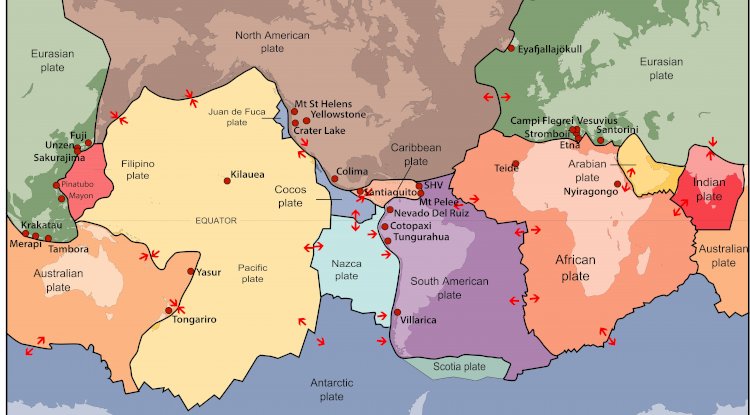
There are three ways in which plates interact: divergence, convergence and lateral slipping. The lines where they meet are called plate boundaries. When two oceanic plates move away from each other or diverge, hot molten metal from the mantle beneath rises to fill the space. It forms an oceanic ridge as it cools. When the divergence occurs on land, like in the East African Rift Valley, the plates eventually move into the sea, but of course, over millions of years! The second type of plate movement is convergence forming a convergent plate boundary. This occurs when two. plates collide. When a heavier oceanic plate collides with a lighter continental plate, the oceanic plate slides under/ the continental plate. The place where the sinking occurs is called a subduction zone. It forms an oceanic trench or deep-sea bed. The sea bed is continuously 'recycled as it rises and sinks and then rises again. Subduction is also a major cause of earthquakes.
When two oceanic plates collide, one is generally pushed under the other, allowing the hot magma in the lower mantle to gush out as an undersea volcano. It can also cause an undersea earthquake. When two continental plates collide since both are equally light. the crust crumples and is pushed upwards or sideways to form mountains. For instance, 50 million years ago, India collided with Asia. The Eurasian plate rode over the Indian plate and formed the mighty Himalayas and the Tibetan plateau. The growth took place in the last 10 million years.
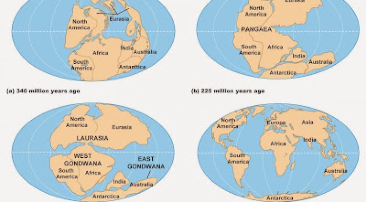
Applying the principles of plate tectonics, scientists can understand the processes that shaped our planet much better than in Wegener's day! Researchers believe that the distance between the east and west Atlantic coasts increases by 3 cm every year. The March 2011 earthquake that struck eastern Japan moved parts of it closer to the western United States because the Pacific plate moved suddenly under the North American plate. Japan sits on the western tip of the North American plate. This pushed the crust forward. The continents are moving 10 centimetres every year. Gradually, the map of the world will change again but it will take millions of years for that to happen!
What's Your Reaction?